
File:Taklamakan Shrouded in Dust (MODIS 2022-04-20).jpg
.jpg)
Size of this preview: 800 × 597 pixels. Other resolutions: 320 × 239 pixels | 640 × 477 pixels | 1,024 × 764 pixels | 1,280 × 955 pixels | 2,560 × 1,910 pixels | 6,770 × 5,050 pixels.
.jpg/960px-Taklamakan_Shrouded_in_Dust_(MODIS_2022-04-20).jpg)
.jpg/330px-Taklamakan_Shrouded_in_Dust_(MODIS_2022-04-20).jpg)
.jpg/1024px-Taklamakan_Shrouded_in_Dust_(MODIS_2022-04-20).jpg)
.jpg/1280px-Taklamakan_Shrouded_in_Dust_(MODIS_2022-04-20).jpg)
.jpg/2560px-Taklamakan_Shrouded_in_Dust_(MODIS_2022-04-20).jpg)
Original file (6,770 × 5,050 pixels, file size: 3.07 MB, MIME type: image/jpeg)
Captions
Captions
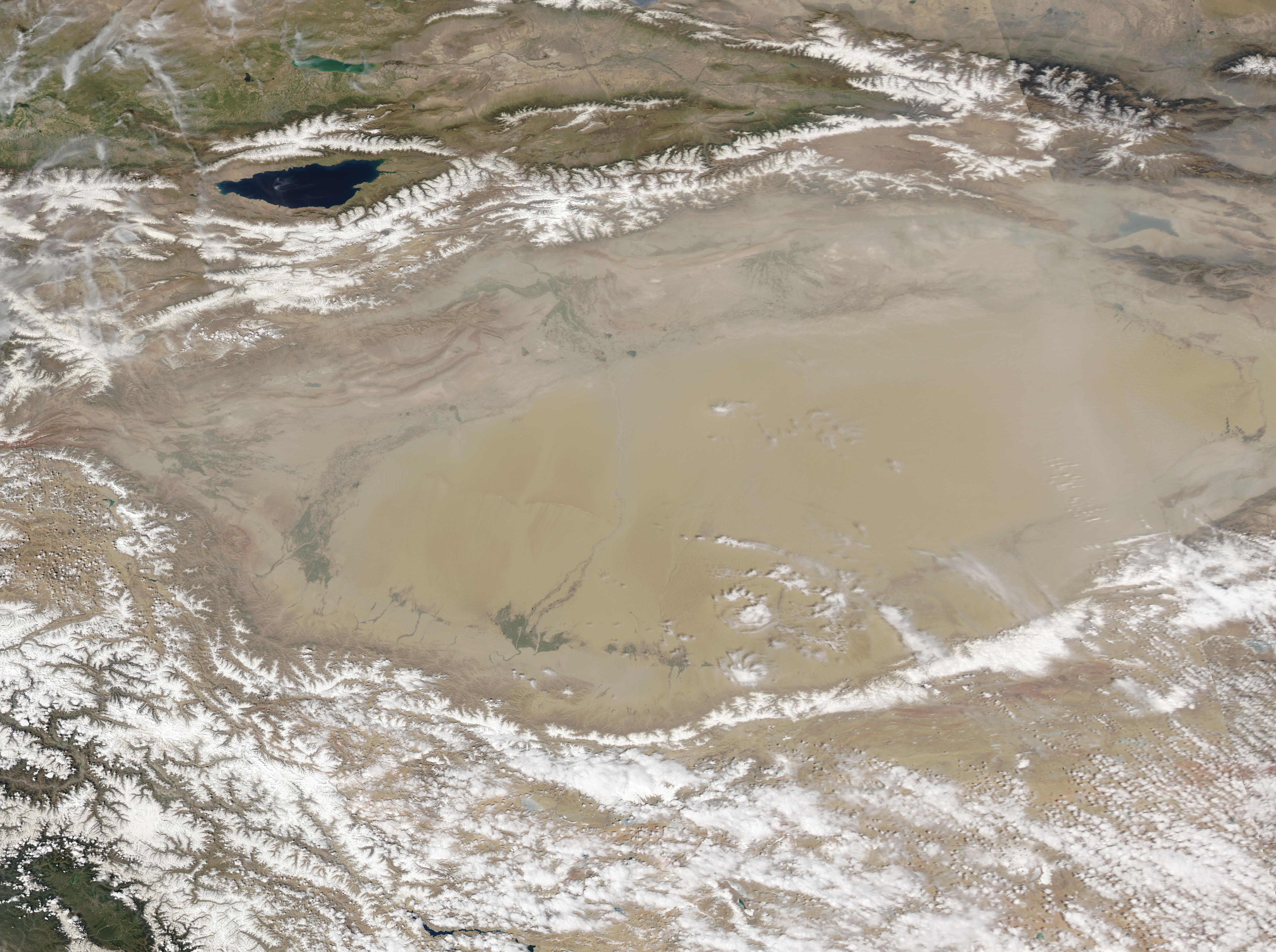
On April 18, 2022, the Moderate Resolution Imaging Spectroradiometer (MODIS) on board NASA’s Aqua satellite acquired a true-color image of the Taklamakan Desert veiled by a large dust storm.
Summary
[edit].jpg&action=edit§ion=1)
| Description |
English: Sitting in western China and cradled on three sides by tall mountain ranges, the Taklamakan Desert is one of the most barren and driest areas on Earth. Created by the rain shadow of the surrounding mountains, parts of the Taklamakan receive only 10 millimeters (0.4 inches) of rainfall in an entire year. It is also the world’s second largest shifting sand desert, with about 85 percent of its area filled with towering sand dunes, measuring up to 200-300 meters (650 to 900 feet) that move with the prevailing winds. Thanks to its location close to frigid Siberia, the Taklamakan Desert experiences some of the Earth’s record cold temperatures in winter. Even in summer, nighttime temperatures remain chilly. Thanks to the topography, strong winds frequently blow across the expansive desert. And these winds create massive sandstorms, especially in the spring and summer.
On April 18, 2022, the Moderate Resolution Imaging Spectroradiometer (MODIS) on board NASA’s Aqua satellite acquired a true-color image of the Taklamakan Desert veiled by a large dust storm. Snow tops the Kunlun Shan mountains to the south and the Tian Shan mountains to the north. Lake Issyk-Kul sits in the Tian Shan mountains of eastern Kyrgyzstan. The air over the mountains is dust-free, allowing a crisp, clear view of the landscape. In sharp contrast, dust covers the entire area over the Taklamakan Desert and, in the east, a band of dust completely obscures the land from view. |
||
| Date | Taken on 18 April 2022 | ||
| Source |
Taklamakan Shrouded in Dust (direct link)
|
||
| Author | MODIS Land Rapid Response Team, NASA GSFC |
| This media is a product of the Aqua mission Credit and attribution belongs to the mission team, if not already specified in the "author" row |
Licensing
[edit].jpg&action=edit§ion=2)
| This file is in the public domain in the United States because it was solely created by NASA. NASA copyright policy states that "NASA material is not protected by copyright unless noted". (See Template:PD-USGov, NASA copyright policy page or JPL Image Use Policy.) | ||
 |
Warnings:
|
File history
Click on a date/time to view the file as it appeared at that time.
| Date/Time | Thumbnail | Dimensions | User | Comment | |
|---|---|---|---|---|---|
| current | 22:07, 9 January 2024 | | 6,770 × 5,050 (3.07 MB) | OptimusPrimeBot (talk | contribs) | #Spacemedia - Upload of http://modis.gsfc.nasa.gov/gallery/images/image04202022_250m.jpg via Commons:Spacemedia |
You cannot overwrite this file.
File usage on Commons
There are no pages that use this file.
.jpg&oldid=1065553607)